
Search By Town
- Ballyvaughan
- Bunratty
- Carron
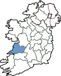
- Corofin
- Doolin
- Doonbeg
- Ennis
- Feakle
- Killaloe
- Lahinch
- Liscannor
- Lisdoonvarna
- Miltown Malbay
- Mountshannon
- Newmarket-on-Fergus
- Quilty
- Whitegate
Search By Map
Burren National Park - Corofin, County Clare
A natural landscape located near Corofin, County Clare
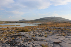
The Burren is one of the finest examples of a Glacio-Karst landscape in the world.
The Burren National Park is located in the southeastern corner of the Burren and is approximately 1500 hectares in size.
It contains examples of all the major habitats within the Burren region including Limestone Pavement, Calcareous Grassland, Hazel scrub, Ash/Hazel Woodland, Turloughs, Lakes, Petrifying Springs, Cliffs and Fen.
The word Burren comes from an Irish word Boíreann meaning a rocky place. This is an appropriate name when you consider the lack of soil cover and the extent of exposed Limestone Pavement. However it has been referred to in the past as Fertile rock due to the mixture of nutrient rich herb and floral species.
The highest point in the park is Knockanes (207 metres) which continues as a curving terraced ridge to Mullaghmór to the south. East of this ridge is an area of extensive, low lying limestone pavement containing a number of semi-permanent lakes. West of this ridge the pavement sweeps down to partially drift-covered ground which gradually rises again to reach the foot of a rocky escarpment. To the south of the park the limestone bedrock disappears under a layer of glacial till. This till area is far more intensively managed for pasture and silage.
There are five marked walking trails in the Park that take you through many different fascinating and beautiful habitats, such as species-rich limestone grasslands, hazel/ash woodlands and limestone pavements.
Directions to Burren National Park
Located near Corofin Village. The trailhead is located at Gortlecka Crossroads.
Sat Nav: 52.996558,-9.037868
See all the visitor attractions in County Clare
Corofin Accommodation Listings
Sorry there is currently no listings for Corofin.
 Add Your Business Here
Would your business benefit by being listed here. If yes then click for more details
New Additions to Ireland View
Clare Guide
Whole Site Navigation
Search By Town
- Ballyvaughan
- Bunratty
- Carron
- Corofin
- Doolin
- Doonbeg
- Ennis
- Feakle
- Killaloe
- Lahinch
- Liscannor
- Lisdoonvarna
- Miltown Malbay
- Mountshannon
- Newmarket-on-Fergus
- Quilty
- Whitegate
Search By Map