
Search By Town
- Annascaul
- Ardfert
- Ballinskelligs
- Ballybunion
- Ballydavid
- Ballyferriter
- Ballyheigue
- Ballylongford
- Caherdaniel
- Cahersiveen
- Camp
- Castlegregory
- Castleisland
- Castlemaine
- Cloghane
- Dingle
- Dunquin
- Glenbeigh
- Glencar
- Kenmare
- Killarney
- Killorglin
- Listowel
- Maharees
- Milltown
- Portmagee
- Sneem
- Tralee
- Ventry
- Waterville
Search By Map
Holiday Accommodation
The Beara Way *
The Beara Way is a 196km, circular walking trail. The trail both starts and ends in Glengarriff.
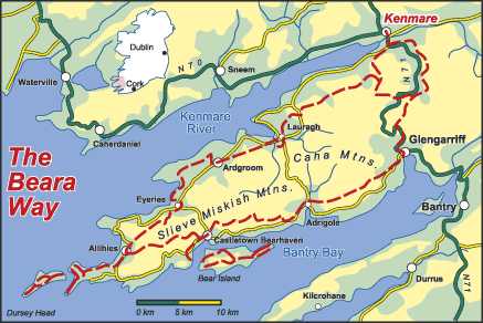
Trail Sections
Glengarriff to Adrigole
Introduces walkers to the wildness of the Beara mountains taking them through a pass between the Sugarloaf and Gowlbeg and along an old medieval road with great views out across Bantry Bay. This route also offers views of Glengariff Harbour. About 9 km road, 4 km track, 3 km mountain path. First and last bits on busy road (care required) R572 Glengarriff to Castletownbere, rest of road quiet; some of mountain path can be wet; passes between Sugarloaf Mountain and Gowlbeg Mountain.
Distance: 16 km
Time Estimate: 5.75 hours
Grade: Moderate
Parking At Start: On street in Glengarriff
Parking At End: Limited parking on street in Adrigole
Adrigole to Castletownbere
This stage takes you up along the southern flanks of Hungry Hill into a valley, crosses two boggy ridges, two more valleys and many streams. Landscape features include the Mare's Tail Waterfall, views out over Bantry Bay and the eatern end of Bere Island. About 5 km road, 7 km track, 10 km open ground. Some on R572 Glengarriff to Castletownbere (care required), other road very quiet; some open ground rough walking.
Distance: 22 km
Time Estimate: 8 hours
Grade: Hard
Parking At Start: Limited parking on street in Adrigole
Parking At End: Parking on street in Castletownbere
Westend Pier to Lighthouse at western end of Bear Island, Signal Tower and to Rerrin
About 4.5 km road, 5.5 km track, 3 km open ground. Roads quiet but can carry fast traffic; open ground quite rough walking; uses old road to lighthouse
Distance: 13 km
Time Estimate: 5.5 hours
Grade: Moderate
Parking At Start: Parking at pier
Parking At End: Parking at pier
Westend Pier to Rerrin along northern side of Bear Island
All road. Roads quiet but can carry fast traffic; passes through more inhabited part of island
Distance: 7 km
Time Estimate: 2.25 hours
Grade: Easy
Parking At Start: Parking at pier
Parking At End: Parking at pier
Circuit (clockwise) of eastern end of Bear Island from Rerrin to Rerrin and there-and-back to Martello Tower
About 6 km road, 2 km track. Roads quiet but can carry fast traffic; steep climb to martello tower; starts and finishes in village of Rerrin
Distance: 8 km
Time Estimate: 2.75 hours
Grade: Easy
Parking At Start: Parking at pier
Parking At End: Parking at pier
Castletownbere to Allihies
This section crosses to Allihies through surroundings which vary from open moorland to thick forestry. The highest point under Knockgour mountain gives a tremendous view westwards across Ballydonegan Bay and out into the Atlantic.About 8 km road, 4.5 km track, 1 km open ground. Road generally quiet except for finish on R575 into Allihies; open ground can be rough walking; steep climb to pass at Knockgour; long descent to Allihies
Distance: 13.5 km
Time Estimate: 5 hours
Grade: Easy
Parking At Start: Parking on street in Castletownbere
Parking At End: Parking on street in Allihies
Allihies to Garinish (White Strand)
This section is a scenic coastal walk that takes you out along the cliffs south of Ballydonegan Bay with marvellous views across to Lamb's Gead on the Iveragh Peninsula, and on to Crow's Head. This section includes a ride on Ireland's only cable car across Dursey Sound to Dursey Island.About 5.5 km road, 2.5 km track, 1.5 km field/open ground. Take care on R575 from Allihies and R572 at Firkeel Gap, other road quiet; steep climb at Foher in fields and open ground; walk direct from Firkeel Gap to White Strand
Distance: 9.5 km
Time Estimate: 3.5 hours
Grade: Easy
Parking At Start: Parking on street in Allihies
Parking At End: Limited parking near White Strand
Circuit from Cable Car to Garinish, Glanarough and Ballynacarriga to Cable Car
About 6 km road, 4 km open ground. Take care on R572 through Firkeel Gap and returning to cable car, other road quiet; open ground can be rough walking; steep climb from cable car
Distance: 10 km
Time Estimate: 3.5 hours
Grade: Moderate
Parking At Start: Parking at cable car
Parking At End: Parking at cable car
Circuit of Dursey Island (clockwise) and there-and-back to Dursey Head
About 8 km road/track, 5 km open ground. Road almost without traffic; spur to end of island remote; easy walking on open ground; exposed in wind and rain
Distance: 13 km
Time Estimate: 5 hours
Grade: Easy
Parking At Start: Parking at cable car
Parking At End: Parking at cable car
Allihies to Eyeries
Landscape features of note include bog asphodel, Coulagh Bay, the Kealincha River.About 4.5 km road, 7 km unsurfaced road, 0.5 km path. Care required on R575 at start in Allihies and last bit on R575/R571 to Eyeries; steep climb up through copper mines and long descent
Distance: 12 km
Time Estimate: 4.5 hours
Grade: Easy
Parking At Start: On street in Allihies
Parking At End: On street in Eyeries
Eyeries to Ballycrovane
Landscape features include meadows and stony foreshores offering views of Coulagh Bay, Eyries Island and Ballycrovane Harbour.About 2.5 km road, 4.5 km cliff-top path. Road quiet but traffic may travel fast; cliff-top path exposed in wind
Distance: 7 km
Time Estimate: 2.5 hours
Grade: Easy
Parking At Start: On street in Eyeries
Parking At End: Limited parking at Ballycrovane
Ballycrovane to Ardgroom
This section will take you past An Cailleach Bheara, Lough Fada, and Glenbeg Lough. It also offers views of the Slieve Miskish Mountains, Kenmare River and Ardgroom and Killnakilloge Harbours.About 3 km road, 1 km track, 3 km open ground. Road generally quiet though traffic may travel fast; rough walking on open ground; quite steep descent off open ground to Ardgroom
Distance: 7 km
Time Estimate: 3 hours
Grade: Moderate
Parking At Start: Limited parking at Ballycrovane
Parking At End: On street in Ardgroom
Ardgroom to Lauragh
Along this section one will encounter views of Ardgroom Harbour, the Kenmare river and the Iveragh Peninsula as well as the dramatic summits of Tooreennamna, Tooth Mountain and Coomacloghane.About 9 km road, 3.5 km path/grassy track. Two stretches of road on R571 requiring care; remainder of road quiet; path/grassy track follows line of old road; descent through forest on path can be wet
Distance: 12.5 km
Time Estimate: 4.5 hours
Grade: Easy
Parking At Start: Parking on street in Ardgroom
Parking At End: Limited parking in Lauragh
Lauragh to Lough Inchiquin
About 6 km road, 1 km track, 3 km open ground. Section avoids R571 on minor road at start; care required crossing R571 and about 0.5 km on it at Drombohilly Lower, remaining road quiet
Distance: 10 km
Time Estimate: 4 hours
Grade: Moderate
Parking At Start: Limited parking at Lauragh
Parking At End: Limited parking on lake shore
Lough Inchiquin to Kenmare
About 10 km road, 1 km track, 4 km open ground. Most of road quiet except for finish on R571 where care required; some of open ground rough walking; open ground section quite remote
Distance: 15 km
Time Estimate: 5.5 hours
Grade: Moderate
Parking At Start: Limited parking on lake shore
Parking At End: On street in Kenmare
Kenmare to Bunane
All road. Generally quiet road along the valley of the Sheen River; section finishes on N71 in Bunane
Distance: 14 km
Time Estimate: 4.25 hours
Grade: Easy
Parking At Start: On street in Kenmare
Parking At End: Limited parking at Bunane
Kenmare to Bunane (via Drombane, West of N71)
All road. Start on R571 and finishing along N71 busy requiring care; remainder of road reasonably quiet; one short steep climb onto pass
Distance: 15 km
Time Estimate: 5.25 hours
Grade: Easy
Parking At Start: On street in Kenmare
Parking At End: Limited parking at Bunane
Bunane to Glengarriff
About 6 km road, 4 km track/path. Bit on N71 and finish on R572 require care; follows line of old road over pass between Esk Mountain and Barraboy Mountain; through woods before reaching Glengariff
Distance: 10 km
Time Estimate: 3.5 hours
Grade: Easy
Parking At Start: Limited parking at Bunane
Parking At End: On street in Glengarriff
* Text and Images; courtesy of Walk Ireland.
Glengarriff
Sorry there is currently no listings for Glengarriff.
Kenmare
Sorry there is currently no listings for Kenmare.
Kerry Listings
To search for County Kerry listings please choose from the links on the left hand side of the screen. These links enable you to search by town, by area, by map or by a full listing. The links on the right hand side of the screen enable you to view County Kerry map, festivals, visitor attractions and other useful information.
Ireland View is constantly improving the service to our visitors to ensure that you enjoy your search on this site and find all the information you require to book your Irish Holiday. If you experience any difficulties please contact the Web Developer directly by clicking on the link in the Other Resources section.
Selection From Our Full Listings
Other Resources
Add to favourites
Contact Us
Add Your Business
Web Developer